Google Earth images of S'pore
-
where to type the longitude all these?
-
[quote]Originally posted by lionnoisy:
[b]Private Runway in Dr No's Island---Absoluetly out of bound!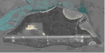
Want to be Pilot of Dr No,dial 1800--youknowfasr.Only the best will
be scrambled for interviewed.Good luck.
wgat island is this???? -
Many Hardened hangar near Official runway.. -
Lion, can u please delete off the pictures of sensitive areas. Although the photos are available in the net, let others find it but please do not lead them to it.
Thx. -
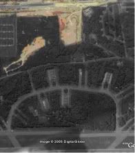
What's in the picture? Where is it?Originally posted by lionnoisy: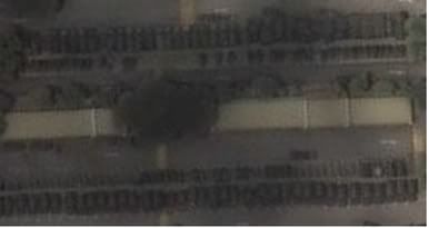
Somethings towed behind trucks like poles?A Stand By Force ready for Action!? -
anyone could find peace vanguard and peace pairie detachment?
-
---
-
foxtrout8:tx.
I think it is ok to pinpoint the obvious assets which
can be observed from satellite for a long time ago.
This can be a road map for air or SOF
attacks,but these also can deter them from attacks!!
They will find it to hard to cause great damages in first strike,
if they can penetrate air defence.They know our strike
back will be very
hard.I dunt know how much more can see from these
images if they pay more,though outdated,
.
Other companies will approach them for better resolution
images long time ago. Products avaiable to Civilians
is usually few years later than military/governmet.
Of course .i agree we shall not pinpoint classified or
not so obvious assets .
2.If they find SG sattelite image is very useful,
though it is outdated,they will find our satellites above
their heads EVERYDAY and almost every hour are irritating .
http://www.sgforums.com/?action=thread_display&thread_id=133774 -
WHO wanna see AREA 51 ????
-
37°14'37.77"N, 115° 46'53.83"WOriginally posted by c0ol_blu3z:WHO wanna see AREA 51 ????
the whole area here belongs to AREA 51...
note the extra long runway..it's use for testing supersonic aircraft -
I can see 2 F16 and what appears like 2 Blackhawks. 2 airliner sized jets and 3 large props craft. Anybody spot X series planes?Originally posted by c0ol_blu3z:37°14'37.77"N, 115° 46'53.83"W
the whole area here belongs to AREA 51...
note the extra long runway..it's use for testing supersonic aircraft -
Don't worry, SAF not so stupid, satellite imaging is so advanced and easily available. Even higher resolution images can be bought for a fee online.Originally posted by foxtrout8:Lion, can u please delete off the pictures of sensitive areas. Although the photos are available in the net, let others find it but please do not lead them to it.
Thx.
SAF knows this, so what they don't want people to see, they'll have a way of hiding them. Those areas are hidden even from the most powerful imaging satellites.
Sudong is an open secret, no big deal liao. But still, exercise caution when dealing with SAF-related images. ISD and MSD are watching...
-
pl tell me asap if i cross the red line.I will buy you a coffee .
Thanks for all comments made on my postings. -
Why don't we post images of foreign bases and have a discussion of what we can deduce from it? It'll be like Cold War intelligence people figuring out enemy strength, resources from satellite images. That would be fun.
-
Very nice pics of pearl harbour.. sharp images n can actually see clearly the sunken Arizona. If anyone bothers to look @ Pearl, can someone tell mi what battleship is moored on Ford island?
-
Google Earth is a public domain service.If areas are seen on GE, when they are not supposed to be seen, then some fellow's head must roll.Originally posted by Zooish:Don't worry, SAF not so stupid, satellite imaging is so advanced and easily available. Even higher resolution images can be bought for a fee online.
SAF knows this, so what they don't want people to see, they'll have a way of hiding them. Those areas are hidden even from the most powerful imaging satellites.
Sudong is an open secret, no big deal liao. But still, exercise caution when dealing with SAF-related images. ISD and MSD are watching...
Anyway, we should post more maps of bases that can be identified, it would be nice, to quote a fellow forumnite, to play Cold War Keyhole imagery spies.
I think these images are actual images from the KH- satellites series of the US DOD, except that they have been retired.Imagine..the KH series was around in the 60s and 70s. -
One fun way I played with the program is to adjust to 20k feet, turning on the terrain function and adjust to a more of less horizontal point of view, by dragging the mouse to make the picture spin in the direction you want, (Takes some pratice to get it spinning slow enough.) I manage to simulate a flight from LA to San Francisco.
 Only thing is that the Golden Gate Bridge is flat
P.S Not advisable to overfly the ocean, can fall alsleep. Oso, you can't change anything during midflight, any mouse clicks on the pidcture would stop the spinning.
Overflying the Himalayas at 20k ft is low level flight. -
good idea... anyone has the image of Kuantan AB....Originally posted by huaichien:Why don't we post images of foreign bases and have a discussion of what we can deduce from it? It'll be like Cold War intelligence people figuring out enemy strength, resources from satellite images. That would be fun. -
U can get the lat and long coordinates online for almost every air force base on the net.
I'll give u a clue where to find that website. It carries a .nl domain.
Those ppl who frequent aviation sites might know which site it is. -
looks like a new runway is being built for paya lebar. look east of the runway, you can see a long stretch of tarmac that is wide enough for aircraft use. and it is aligned with the main runway as well.
-
omg, SBAB is so clear!
-
do u noe where does the US military ships visit secretively? it is not Changi Naval Base..its somewhere else..heehee..
-
or u noe the air force base in the middle of the ocean?where the B2s are?
-
Do you mean this place?Originally posted by y33bas:do u noe where does the US military ships visit secretively? it is not Changi Naval Base..its somewhere else..heehee..
I've been there as a civilian when some British and French warships were visiting some years back. One of them was the LaFayette class stealth frigate and they let us board it for a very limited tour. -
Google Earth images are totally way outdated !!!
Yep seem cool to see the fokkers about 4 of the in changi, yep paya lebar can even see 1 north west airline plane possible rented by US airforce park there , with 4-5 c-130 ....
But do you know how outdated those pictures are ? Very very outdated ... by look seem to be then 1 year to 3 yrs because, if you look carefully at some places, they are still empty spaces, which if nowadays, buildings already builded and in used .